
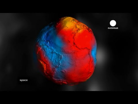
GOCE: Geoid
Launched on 17 March 2009, ESA’s Gravity field and steady-state Ocean Circulation Explorer (GOCE) is bringing about a whole new level of understanding of one of Earth’s most fundamental forces of nature: the gravity field. Dubbed the ‘Formula 1’ of satellites, GOCE is mapping Earth’s gravity field in unprecedented detail.
This has given rise to a unique model of the ‘geoid’, which is the surface of an hypothetical global ocean in the absence of tides and currents, shaped only by gravity. It is a crucial reference for measuring ocean circulation and sea-level change, which are affected by climate change.
The colours in the image represent deviations in height ( -100 m to + 100 m) from an ideal geoid. The blue colours represent low values and the reds/yellows represent high values.
See also: Earth’s gravity revealed in unprecedented detail at: http://www.esa.int/esaCP/SEM1AK6UPLG_index_0.html

I've a question…the "ideal geoid" in the description is the ellipsoid??????? thx
sri lanka is the best place
00:19 let the tampon release
Wow, Earth is sure ugly. I always thought it was a pretty and smooth sphere.
It is. It's by comparison smoother than a Billiard Ball. This is an exaggerated representation of the gravitational field near the surface of Earth.
It's so~ keen! B-) B-) B-)
So why is the moon a perfect circle it has no water.
If this is real shape of earth what about nasa photo from moon?
Hello
what is the difference between Geoidundulation and altitude anomaly.
Eu descobri isso vendo Google earth, e descobri coisas assustadoras tamb?m.
So Earth looks more like heart, with radiation belts being similar to circulatory system, where instead of blood are particle of energy?
The geoid undulations are quite small. They have been exaggerated in these pictures to make them clearer to see. From space the Earth looks pretty much like a sphere.
Why always the big hole in Antarctica?
Oblate spheroid is the shape of earth. Its like a pear.
This explains the wobble.