
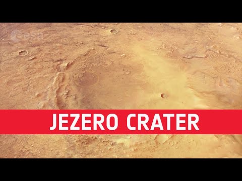
Fly over Mawrth Vallis
This movie, based on images taken by ESA?s Mars Express, highlights Mawrth Vallis, a 600 km-long, 2 km-deep outflow channel at the boundary of the southern highlands and the northern lowlands of Mars.
The movie begins at the mouth of the channel in Chryse Planitia, and heads towards the apparent source region in the Arabia Terra highlands.
The 4 billion year-old plateau is characterised by many impact craters, indicative of its great age.
Zooming in, patches of light and dark deposits are revealed. The light-toned layered sediments are among the largest outcrops of clay minerals ? phyllosilicates ? on Mars. Their presence indicates the presence of liquid water in the past.
The variety of water-bearing minerals and the possibility that they might contain a record of an ancient, habitable environment on Mars led scientists to propose Mawrth Vallis as a candidate landing site for the ExoMars 2020 mission.
The animation is based on a colour mosaic and digital terrain model derived from data collected by the high-resolution stereo camera on Mars Express and released earlier this year.
More info:
http://exploration.esa.int/mars/54721-mawrth-vallis/
http://www.esa.int/spaceinimages/Images/2016/09/Mawrth_Vallis_martian_mosaic
Credits: ESA/DLR/FU Berlin, CC BY-SA 3.0 IGO
ningu?m fala portugu?s aqui?/nobody speak portuguese here?
The evolution and research and creativity.
Causing various systems, a high technology.
For convenience and comfort, and fast. , In informed.
The possibility of the solar system and around the world.
And to communicate comfortably, both audio and video.
????? ?? ??????? ???? ?? ????? ?? ???? ? ?? ????? ??? ??? ???????? ?????? ?? ????? .
??????? ????? ?? ???? ???? ???? ? ???????????? ?????()))))
????? ???????????? ?? ??????????? ?????????? ??????????, ?????????? ???? ? 2003 ???? 🙂
Perfectly! But it was even better to insert in the video computer graphics scale. Schematic contours indicate, for example, the size of the aerodrome runway, the height of the Empire Sta- tion Building, etc.
ffs its FAKE as F**k CGI Wake up
"It's photoshopped, …because it has to be", NASA.
Space is fake. Watch Russianvids or O.D.D. Reality channels.
???????? ???????. ?? ????????? ??. ???? ??????? ??? ? ??????? ????? ??? ???????.
Waoo
Mark Watney was there.